Dossier Precision fishing
In the world of agriculture, precision technology and high-tech applications are becoming more and more commonplace. The fishing industry is going through the same evolution: hardware, software and apps are being developed for use in catching, processing, on-board operations and marketing, which opens up a world of possibilities for fishermen and researchers.
What does ILVO do?
-
 IILVO designs and tests equipment and software for the collection of data on fish stocks, socio-economic parameters, etc.

By precision fishing we mean the development and application of innovative techniques and high-tech solutions for fisheries. These should allow for more and better data collection, more selective fishing with less environmental impact, more efficient operation and management of vessels and fishing activities, and better valorization.
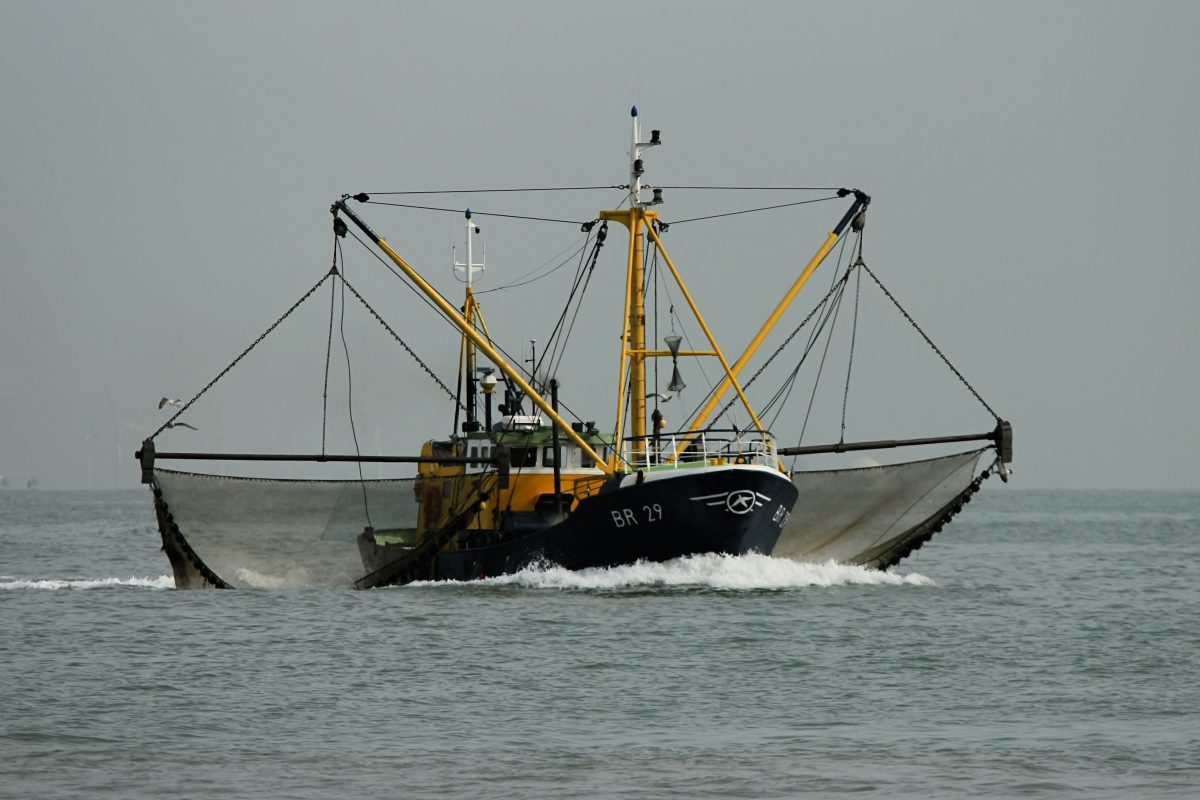
Catch and precision
Commercial pulse fishing as such has been banned, but the potential of the technology remains valid and is not limited to increasing the catch. For example, trials using small electrodes in an escape panel in the belly of the net have proven that it is possible to release more unwanted by-catch without losing commercially valuable flatfish. Indeed, sole that try to worm their way through the holes in the escape panel receive a small shock and thus move further towards the end of the net. Similar results are obtained with LED lights in escape panels: they ensure that small plaice do not get caught, while the large marketable sole remain in the net . Within project COMBITUIG, ILVO investigates possible applications of these and other new technologies using catch comparisons on board research vessels.
Processing and precision
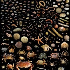
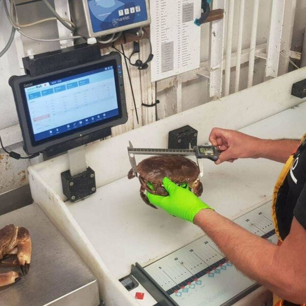
Currently, catches are mapped through a marine observer monitoring program. That sampling approach provides high quality data but is limited in scope, so for less common fish species such as turbot, brill and some ray species, there is a lack of data on their distribution and densities in fishing areas. Machine Vision, an automatic system for image recognition of fish species on board, may be a solution. In this way, fishing vessels can collect their own data, a principle called self-sampling.
Within the VISIM project, scientists and fishermen are investigating the possibilities of setting up an image recognition system aboard the vessel. That system is being developed by scientists using both classical image recognition methods and artificial intelligence. The software developed is already capable of measuring fish transported on a conveyor belt with an average degree of accuracy of under 3mm under standardized conditions. The next step is the development of the species recognition software, where a large number of images are collected of the species to be identified (sole, plaice, etc.). These images will be fed to the machine learning software, which should then be able to identify fish as they come into view. The final step is to install and test the system on board.
Successful implementation on board fishing vessels, and possibly also in the fish market, could immediately shift data collection in fisheries up a few gears. The new system could also be profitable for fishermen: for example, based on real-time measurements of the length distributions per catch, they could estimate what the most interesting fishing grounds are at any given time.
The ultimate goal of the system, in the long term, is to analyze the raw catch as a function of data collection. So it is not about control, nor just about fish. Data on all species, including sea stars, shrimps and the like, will be collected in order to visualize the ecosystem as a whole. Because scientists have known it for a long time: fishing catches provide a wealth of information about the ecosystems they come from, and about variations in space and time. Imagine being able to pour all that information into a predictive model, much like the models that generate our weather forecasts, and have them tell you exactly where the interesting fish are, or when vulnerable species are coming together to reproduce. That's information that every fisherman and ecosystem manager could use.
Operationality and precision
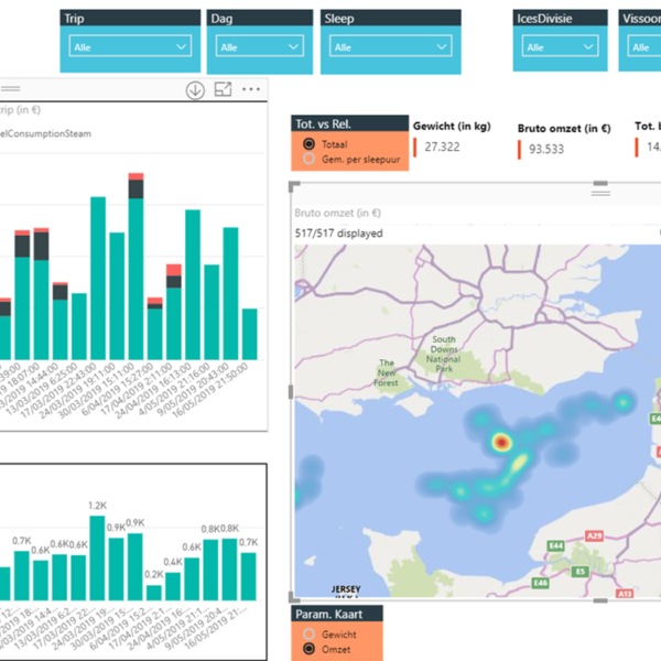
Skippers and shipowners need quick feedback on the economic performance of their vessel - think of yield per trip, catch composition and fuel costs. Through automated sensor data it is possible to generate a 'live view' of this, and even to start developing online tools. And that is precisely the goal of the VIStools trajectory, a sequence of projects that sees vessels as data platforms. What is special is that the trajectory is set up co-creatively, as a collaboration between the fishing industry and science.
The central objective is to collect fisheries information automatically on board each vessel, the 'live view'. This provides information from the sensors without intermediate algorithms, and offers skippers and shipowners a real-time impression of the situation on board. VISTOOLS Analytics goes one step further: the data from the sensors is centralized and linked to existing data platforms. Linking this new source of fisheries information with existing data allows the development of a number of accessible, informative tools for fishermen on board and online. The information is transmitted anonymously, linked to external data sources and displayed on maps, called 'heat maps'. These display information such as the value of the catch, or the turnover per day. The researchers and fishing partners are also developing an electronic fish hold plan that allows the content and location of fish boxes in the hold to be tracked via an application on a tablet.
For scientists, these algorithms also open up new opportunities for research. For example, the data provide insights into where and when fish are caught, and data from surface water temperature sensors are particularly valuable to climate scientists.
Marketing and precision
The fishing industry has been making efforts to make the sector more sustainable for about a decade. For example, vessels use up to 40 percent less fuel, nets have been adapted to reduce bycatch and the gears have been made lighter to cause less disturbance to the ecosystem. ILVO, together with Valduvis - the valorization of sustainably caught fish - has developed a measuring instrument that can objectively and precisely measure these efforts and that should make fisheries even more sustainable.
Met de Valduvis-tool worden elf indicatoren in kaart gebracht waardoor het een score kan toekennen aan een vaartuig, een visserijvloot of een bepaald vlootsegment. Reders en vissers kunnen op basis van de individuele scores over de diverse indicatoren, en onder wetenschappelijke begeleiding van het ILVO, zoeken hoe zij hun globale score kunnen verbeteren.
Op www.valduvis.be shipowners can track their own score, the government can monitor the industry, and buyers and consumers can see if their fish is sustainably caught. At the fish auction, buyers can see if the traded fish comes from a sustainable fishing vessel. The Valduvis tool has been encapsulated in an improvement process called 'Visserij Verduurzaamt', which also recognizes the efforts that the shipowners are already making.